Tropical tracker: Timeline of the 2025 Atlantic Hurricane Season
This story is part of the KXAN Data Hub, where numbers help tell the whole story.We’ve created several data-driven stories and databases on topics including weather and climate, politics, education, sports and growth in Texas. Each story in the KXAN Data Hub is updated as new data becomes available.
AUSTIN (KXAN) — Each year, the Atlantic hurricane season officially runs from June 1 through Nov. 30. This year is expected to be active, with the National Oceanic and Atmospheric Administration (NOAA) predicting a 60% chance of an above-average season.
Hurricane history: How many storms have made landfall in Texas?
Follow along as we track each storm throughout hurricane season. Looking for the 2024 season? Click here.
Hurricane history: Which Atlantic hurricane names have been retired?
Tropical Storm Andrea
June 24, 10 a.m.: Tropical Storm Andreaformed in the Atlantic Ocean, about 1,205 miles west of the Azores. Andrea had maximum sustained winds of 40 mph and was moving east-northeast at 17 mph.June 24, 10 p.m.:Tropical Storm Andreadissipatedabout 985 miles west of the Azores.
Tropical Storm Barry
June 28, 4 p.m.: Tropical Depression Twoformed in the Bay of Campeche, about 240 miles east-southeast of Tuxpan, Mexico. TD Two had maximum sustained winds of 30 mph and was moving west-northwest at 7 mph.June 29, 10 a.m.:Tropical Depression Two strengthened intoTropical Storm Barryabout 90 miles east-southeast of Tuxpan, Mexico. Barry had maximum sustained winds of 40 mph and was moving northwest at 6 mph.June 29, 1 p.m.:Tropical Storm Barry reached itsmaximum intensity, with 45 mph winds.June 29, 10 p.m.:Tropical Storm Barry was downgraded to atropical depressionabout 15 miles south-southeast of Tampico, Mexico, aftermaking landfallon the east coast of Mexico. Barry had maximum sustained winds of 35 mph and was moving northwest at 9 mph.June 30, 4 a.m.:Tropical Depression Barrydissipatedabout 100 miles northeast of Tampico, Mexico.
Tropical Storm Chantal
July 4, 4 p.m.: Tropical Depression Threeformed off the southeast U.S. coast, about 150 miles south-southeast of Charleston, South Carolina. TD Three had maximum sustained winds of 35 mph and was moving north at 2 mph.July 5, 7 a.m.:Tropical Depression Three strengthened intoTropical Storm Chantalabout 150 miles south-southeast of Charleston, South Carolina. Chantal had maximum sustained winds of 40 mph and was moving north at 2 mph.July 6, 1 a.m.:Tropical Storm Chantal reached itsmaximum intensity, with 60 mph winds.July 6, 4 a.m.:Tropical Storm Chantalmade landfallnear Litchfield Beach, South Carolina. Chantal had maximum sustained winds of 50 mph and was moving north-northwest at 8 mph.July 6, 10 a.m.:Tropical Storm Chantal was downgraded to atropical depressionabout 20 miles southwest of Lumberton, North Carolina. Chantal had maximum sustained winds of 35 mph and was moving north at 9 mph.July 7, 10 a.m.:Tropical Depression Chantal became apost-tropical cycloneabout 30 miles north-northeast of Newport News, Virginia. Chantal had maximum sustained winds of 30 mph and was moving northeast at 17 mph.
Tropical Storm Dexter
Aug. 3, 10 p.m.: Tropical Storm Dexterformed in the Atlantic Ocean, about 300 miles west-northwest of Bermuda. Dexter had maximum sustained winds of 45 mph and was moving east-northeast at 12 mph.Aug. 7, 10 a.m.:Tropical Storm Dexter became anextratropical lowabout 390 miles south-southeast of Cape Race, Newfoundland. Dexter had maximum sustained winds of 60 mph and was moving east-northeast at 17 mph.
Hurricane Erin
Aug. 11, 10 a.m.: Tropical Storm Erinformed in the Atlantic Ocean, about 280 miles west-northwest of Cabo Verde. Erin had maximum sustained winds of 45 mph and was moving west at 20 mph.Aug. 15, 10 a.m.:Tropical Storm Erin strengthened into aCategory 1 hurricaneabout 460 miles east of the northern Leeward Islands. Erin had maximum sustained winds of 75 mph and was moving west-northwest at 18 mph.Aug. 15, 10 p.m.:Hurricane Erin strengthened into aCategory 2 hurricaneabout 250 miles east-northeast of Anguilla. Erin had maximum sustained winds of 100 mph and was moving west-northwest at 17 mph.Aug. 16, 4 a.m.:Hurricane Erin strengthened into aCategory 3 hurricaneabout 170 miles northeast of Anguilla. Erin had maximum sustained winds of 120 mph and was moving west-northwest at 20 mph.Aug. 16, 4:50 a.m.:Hurricane Erin strengthened into aCategory 4 hurricaneabout 150 miles northeast of Anguilla. Erin had maximum sustained winds of 130 mph and was moving west-northwest at 20 mph.Aug. 16, 10:20 a.m.:Hurricane Erin strengthened into aCategory 5 hurricaneabout 105 miles north of Anguilla. Erin had maximum sustained winds of 160 mph and was moving west at 17 mph.Aug. 16, 7 p.m.:Hurricane Erin was downgraded to aCategory 4 hurricaneabout 160 miles northwest of Anguilla. Erin had maximum sustained winds of 150 mph and was moving west at 15 mph.Aug. 17, 1 a.m.:Hurricane Erin was downgraded to aCategory 3 hurricaneabout 140 miles north of San Juan, Puerto Rico. Erin had maximum sustained winds of 125 mph and was moving west-northwest at 14 mph.Aug. 17, 10 p.m.:Hurricane Erin strengthened into aCategory 4 hurricaneabout 130 miles east-northeast of Grand Turk Island. Erin had maximum sustained winds of 130 mph and was moving northwest at 12 mph.Aug. 18, 10 p.m.:Hurricane Erin was downgraded to aCategory 3 hurricaneabout 690 miles southwest of Bermuda. Erin had maximum sustained winds of 125 mph and was moving northwest at 8 mph.Aug. 19, 7 a.m.:Hurricane Erin was downgraded to aCategory 2 hurricaneabout 665 miles southwest of Bermuda. Erin had maximum sustained winds of 110 mph and was moving northwest at 7 mph.Aug. 22, 1 a.m.:Hurricane Erin was downgraded to aCategory 1 hurricaneabout 400 miles north-northwest of Bermuda. Erin had maximum sustained winds of 90 mph and was moving northeast at 22 mph.Aug. 22, 4 p.m.:Hurricane Erin became apost-tropical cycloneabout 605 miles north-northeast of Bermuda. Erin had maximum sustained winds of 90 mph and was moving east-northeast at 33 mph.
Tropical Storm Fernand
Aug. 23, 4 p.m.: Tropical Storm Fernandformed in the Atlantic Ocean, about 405 miles south-southeast of Bermuda. Fernand had maximum sustained winds of 40 mph and was moving north at 15 mph.Aug. 25, 10 a.m.:Tropical Storm Fernand reached itsmaximum intensity, with 60 mph winds.Aug. 28, 4 a.m.:Tropical Storm Fernand became apost-tropical cycloneabout 635 miles east-southeast of Cape Race, Newfoundland. Fernand had maximum sustained winds of 45 mph and was moving east-northeast at 23 mph.
Hurricane Gabrielle
Sept. 17, 4 a.m.: Tropical Depression Sevenformed in the Atlantic Ocean, about 1,185 miles east-southeast of the Northern Leeward Islands. TD Seven had maximum sustained winds of 35 mph and was moving west at 13 mph.Sept. 17, 10 a.m.:Tropical Depression Seven strengthened intoTropical Storm Gabrielleabout 1,085 miles east of the Northern Leeward Islands. Gabrielle had maximum sustained winds of 45 mph and was moving north-northwest at 22 mph.Sept. 21, 4 p.m.:Tropical Storm Gabrielle strengthened into aCategory 1 hurricaneabout 320 miles southeast of Bermuda. Gabrielle had maximum sustained winds of 75 mph and was moving north-northwest at 10 mph.Sept. 22, 8 a.m.:Hurricane Gabrielle strengthened into aCategory 3 hurricaneabout 195 miles southeast of Bermuda. Gabrielle had maximum sustained winds of 120 mph and was moving north at 10 mph.Sept. 22, 4 p.m.:Hurricane Gabrielle strengthened into aCategory 4 hurricaneabout 180 miles east-southeast of Bermuda. Gabrielle had maximum sustained winds of 140 mph and was moving north-northeast at 12 mph.Sept. 23, 7 p.m.:Hurricane Gabrielle was downgraded to aCategory 3 hurricaneabout 580 miles east-northeast of Bermuda. Gabrielle had maximum sustained winds of 125 mph and was moving east-northeast at 21 mph.Sept. 24, 4 a.m.:A Hurricane Warning was issued for the Azores.Sept. 24, 10 a.m.:Hurricane Gabrielle was downgraded to aCategory 2 hurricaneabout 1,200 miles west of the Azores. Gabrielle had maximum sustained winds of 110 mph and was moving east-northeast at 25 mph.Sept. 24, 10 p.m.:Hurricane Gabrielle was downgraded to aCategory 1 hurricaneabout 855 miles west of the Azores. Gabrielle had maximum sustained winds of 85 mph and was moving east at 31 mph.Sept. 25, 10 a.m.:Hurricane Gabrielle remained a Category 1 hurricane about 455 miles west of the Azores. Gabrielle had maximum sustained winds of 75 mph and was moving east at 32 mph.Sept. 25, 4 p.m.:Hurricane Gabrielle became apost-tropical cycloneabout 265 miles west-southwest of the Azores. Gabrielle had maximum sustained winds of 70 mph and was moving east at 31 mph.
Hurricane Humberto
Sept. 24, 4 p.m.: Tropical Storm Humbertoformed in the Atlantic Ocean, about 550 miles east-northeast of the northern Leeward Islands. Humberto had maximum sustained winds of 40 mph and was moving west-northwest at 15 mph.Sept. 26, 4 a.m.:Tropical Storm Humberto strengthened into aCategory 1 hurricaneabout 465 miles northeast of the northern Leeward Islands. Humberto had maximum sustained winds of 75 mph and was moving northwest at 3 mph.Sept. 26, 4 p.m.:Hurricane Humberto strengthened into aCategory 3 hurricaneabout 430 miles northeast of the northern Leeward Islands. Humberto had maximum sustained winds of 115 mph and was moving west-northwest at 5 mph.Sept. 26, 10 p.m.:Hurricane Humberto strengthened into aCategory 4 hurricaneabout 390 miles northeast of the northern Leeward Islands. Humberto had maximum sustained winds of 145 mph and was moving west-northwest at 7 mph.Sept. 27, 4 p.m.:Hurricane Humberto strengthened into aCategory 5 hurricaneabout 350 miles north-northeast of the northern Leeward Islands. Humberto had maximum sustained winds of 160 mph and was moving west-northwest at 10 mph.Sept. 28, 4 a.m.:Hurricane Humberto was downgraded to aCategory 4 hurricaneabout 585 miles south of Bermuda. Humberto had maximum sustained winds of 155 mph and was moving west-northwest at 13 mph.Sept. 29, 10 p.m.:Hurricane Humberto was downgraded to aCategory 3 hurricaneabout 265 miles southwest of Bermuda. Humberto had maximum sustained winds of 115 mph and was moving north-northwest at 14 mph.Sept. 30, 4 a.m.:Hurricane Humberto was downgraded to aCategory 2 hurricaneabout 275 miles west of Bermuda. Humberto had maximum sustained winds of 100 mph and was moving north-northwest at 17 mph.Sept. 30, 10 a.m.:Hurricane Humberto was downgraded to aCategory 1 hurricaneabout 300 miles west of Bermuda. Humberto had maximum sustained winds of 80 mph and was moving north-northwest at 18 mph.Oct. 1, 10 a.m.:Hurricane Humbertodissipatedabout 340 miles north-northeast of Bermuda.
Hurricane Imelda
Sept. 26, 4 p.m.:The National Weather Service identifiedPotential Tropical Cyclone Nine, about 55 miles north-northwest of the eastern tip of Cuba. PTC Nine had maximum sustained winds of 35 mph and was moving northwest at 9 mph. A Tropical Storm Warning was issued for the central Bahamas.Sept. 27, 4 a.m.:A Tropical Storm Warning was issued for portions of the northwestern Bahamas.Sept. 27, 10 a.m.: Tropical Depression Nineformed about 180 miles northwest of the eastern tip of Cuba. TD Nine had maximum sustained winds of 35 mph and was moving northwest at 6 mph.Sept. 28, 1 p.m.:Tropical Depression Nine strengthened intoTropical StormImeldaabout 95 miles west-northwest of the central Bahamas. Imelda had maximum sustained winds of 40 mph and was moving north at 7 mph.Sept. 30, 7 a.m.:Tropical Storm Imelda strengthened into aCategory 1 hurricaneabout 180 miles north of Great Abaco Island, Bahamas. Imelda had maximum sustained winds of 75 mph and was moving northeast at 7 mph.Sept. 30, 10 a.m.:A Hurricane Warning was issued for Bermuda.Oct. 1, 10 a.m.:Hurricane Imelda strengthened into aCategory 2 hurricaneabout 340 miles west-southwest of Bermuda. Imelda had maximum sustained winds of 100 mph and was moving east-northeast at 20 mph.Oct. 2, 1 a.m.:Hurricane Imelda was downgraded to aCategory 1 hurricaneabout 80 miles east-northeast of Bermuda. Imelda had maximum sustained winds of 90 mph and was moving east-northeast at 30 mph.Oct. 2, 10 a.m.:Hurricane Imelda became apost-tropical cycloneabout 315 miles east-northeast of Bermuda. Imelda had maximum sustained winds of 75 mph and was moving east-northeast at 29 mph.
Tropical Storm Jerry
Oct. 7, 10 a.m.: Tropical Storm Jerryformed in the Atlantic Ocean, about 1,315 miles east-southeast of the northern Leeward Islands. Jerry had maximum sustained winds of 45 mph and was moving west at 24 mph.Oct. 8, 7 p.m.:Tropical Storm Jerry reached itsmaximum intensity, with 65 mph winds.Oct. 9, 10 a.m.:A Tropical Storm Warning was issued for Barbuda.Oct. 9, 1 p.m.:A Tropical Storm Warning was issued for Anguilla, St. Barthelemy, St. Martin and Sint Maarten.Oct. 9, 2:20 p.m.:A Tropical Storm Warning was issued for Guadeloupe.Oct. 11, 4 p.m.:Tropical Storm Jerrydissipatedabout 330 miles south-southeast of Bermuda.
Subtropical Storm Karen
Oct. 9, 10 p.m.: Subtropical Storm Karenformed in the Atlantic Ocean, about 545 miles north-northwest of the Azores. Karen had maximum sustained winds of 45 mph and was moving northeast at 9 mph.Oct. 10, 4 p.m.: Subtropical Storm Karen became apost-tropical cycloneabout 675 miles north-northeast of the Azores. Karen had maximum sustained winds of 45 mph and was moving north-northeast at 16 mph.
Tropical Storm Lorenzo
Oct. 13, 4 a.m.: Tropical Storm Lorenzoformed in the Atlantic Ocean, about 1,095 miles west of Cabo Verde. Lorenzo had maximum sustained winds of 45 mph and was moving northwest at 17 mph.Oct. 13, 10 p.m.:Tropical Storm Lorenzo reached itsmaximum intensity, with 60 mph winds.Oct. 15, 4 p.m.:Tropical Storm Lorenzodissipatedabout 1,300 miles west-northwest of Cabo Verde.
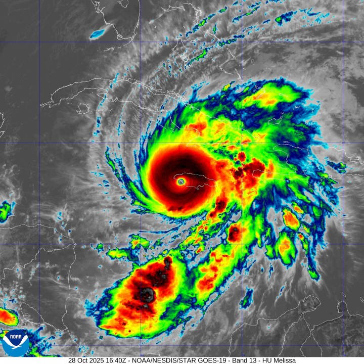
Hurricane Melissa
Oct. 21, 10 a.m.: Tropical Storm Melissaformed in the Caribbean Sea, about 300 miles south of Port-au-Prince, Haiti. Melissa had maximum sustained winds of 50 mph and was moving west at 14 mph.Oct. 23, 7 a.m.:A Tropical Storm Warning was issued for Jamaica.Oct. 23, 1 p.m.:A Tropical Storm Warning was issued for the southern peninsula of Haiti from Port-au-Prince to the border with the Dominican Republic.Oct. 24, 10 p.m.:A Hurricane Warning was issued for Jamaica.Oct. 25, 1 p.m.:Tropical Storm Melissa strengthened into aCategory 1 hurricaneabout 145 miles southeast of Kingston, Jamaica. Melissa had maximum sustained winds of 75 mph and was moving west-northwest at 1 mph.Oct. 25, 7 p.m.:Hurricane Melissa strengthened into aCategory 2 hurricaneabout 130 miles southeast of Kingston, Jamaica. Melissa had maximum sustained winds of 100 mph and was moving west at 3 mph.Oct. 25, 10 p.m.:Hurricane Melissa strengthened into aCategory 3 hurricaneabout 125 miles south-southeast of Kingston, Jamaica. Melissa had maximum sustained winds of 115 mph and was moving west at 3 mph.Oct. 26, 4 a.m.:Hurricane Melissa strengthened into aCategory 4 hurricaneabout 120 miles south-southeast of Kingston, Jamaica. Melissa had maximum sustained winds of 140 mph and was moving west at 5 mph.Oct. 26, 4 p.m.:A Hurricane Warning was issued for the provinces of Granma, Santiago de Cuba, Guantánamo and Holguín in Cuba. A Tropical Storm Warning was issued for the province of Las Tunas.Oct. 26, 10 p.m.:A Tropical Storm Warning was issued for Haiti north of Port-au-Prince to the border with the Dominican Republic.Oct. 27, 4 a.m.:Hurricane Melissa strengthened into aCategory 5 hurricaneabout 130 miles south-southwest of Kingston, Jamaica. Melissa had maximum sustained winds of 160 mph and was moving west at 3 mph.Oct. 27, 4 p.m.:A Hurricane Warning was issued for the southeastern and central Bahamas. A Tropical Storm Warning was issued for the Turks and Caicos Islands.Oct. 28, 9 a.m.:Hurricane Melissa reached itsmaximum intensity, with 185 mph winds. A Hurricane Warning was issued for the province of Las Tunas in Cuba. A Tropical Storm Warning was issued for the province of Camagüey.Oct. 28, 12 p.m.:Hurricane Melissamade landfallnear New Hope, Jamaica, as a Category 5 hurricane. Melissa had maximum sustained winds of 185 mph and was moving north-northeast at 9 mph.Oct. 28, 3 p.m.:Hurricane Melissa was downgraded to aCategory 4 hurricaneabout 10 miles south of Montego Bay, Jamaica. Melissa had maximum sustained winds of 150 mph and was moving north-northeast at 8 mph.Oct. 28, 7 p.m.:Hurricane Melissa was downgraded to aCategory 3 hurricaneabout 50 miles east-northeast of Montego Bay, Jamaica. Melissa had maximum sustained winds of 125 mph and was moving north-northeast at 8 mph.Oct. 28, 10 p.m.:Hurricane Melissa re-strengthened into aCategory 4 hurricaneabout 110 miles southwest of Guantánamo, Cuba. Melissa had maximum sustained winds of 130 mph and was moving northeast at 9 mph.Oct. 29, 1 a.m.:Hurricane Melissa was downgraded to aCategory 3 hurricaneabout 80 miles west-southwest of Guantánamo, Cuba. Melissa had maximum sustained winds of 125 mph and was moving northeast at 10 mph.Oct. 29, 2:10 a.m.:Hurricane Melissamade landfallnear Chivirico, Cuba, as a Category 3 hurricane. Melissa had maximum sustained winds of 120 mph and was moving northeast at 10 mph.Oct. 29, 7 a.m.:Hurricane Melissa was downgraded to aCategory 2 hurricaneabout 45 miles northwest of Guantánamo, Cuba. Melissa had maximum sustained winds of 105 mph and was moving north-northeast at 14 mph.Oct. 29, 4 p.m.:Hurricane Melissa was downgraded to aCategory 1 hurricaneabout 80 miles southeast of the central Bahamas. Melissa had maximum sustained winds of 90 mph and was moving northeast at 16 mph.Oct. 29, 10 p.m.:Hurricane Melissa re-strengthened into aCategory 2 hurricaneabout 105 miles east-northeast of the central Bahamas. Melissa had maximum sustained winds of 100 mph and was moving north-northeast at 21 mph.Oct. 31, 1 a.m.:Hurricane Melissa was downgraded to aCategory 1 hurricaneabout 150 miles north-northwest of Bermuda. Melissa had maximum sustained winds of 90 mph and was moving northeast at 40 mph.Oct. 31, 10 a.m.:Hurricane Melissa became apost-tropical cycloneabout 520 miles north-northeast of Bermuda. Melissa had maximum sustained winds of 85 mph and was moving northeast at 48 mph.
Copyright 2025 Nexstar Media, Inc. All rights reserved. This material may not be published, broadcast, rewritten, or redistributed.
For the latest news, weather, sports, and streaming video, head to KXAN Austin.